Location· CityMETER · Bangkok
Bangkok: what the street network says about reaching the door
Road Network ArchetypesBangkok’s RoadDNA view displays a mean Dead-end Ratio indicator of 40%. It draws attention beyond the main road to the connections approaching a destination: the entrance to a side street, a turning point and the route to the door.
A view inside CityMETER
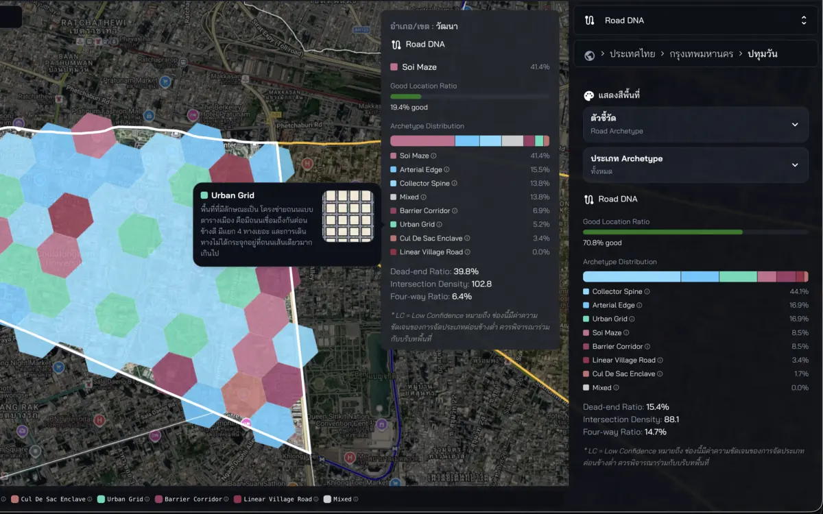
Bangkok · RoadDNA inspected on 10 October 2026 · 40% is the displayed mean model indicator.
- Data period
- Read the details in sources
- Coverage
- Inspected Bangkok view
- Level of detail
- Read the details in sources
- Publisher
- CityMETER — derived model
Distance and connection answer different questions
Choosing a collection point, shop or service location often begins with a neighbourhood name and a distance. Planning the approach adds a second layer: how the smaller streets connect. RoadDNA gives that discussion a starting point in Bangkok’s network patterns. Look around a destination and ask whether several streets connect through the area or whether access gathers around a single entrance. The question becomes spatial and specific. A team can identify the connection it wants to examine instead of treating every place within the same distance as the same proposition.
Let the intended journey shape the enquiry
A pedestrian, a driving customer and a delivery vehicle bring different questions to the same street pattern. A shop enquiry might focus on the approach to its entrance. A service visit might focus on the order of stops and places where a vehicle has to turn back. Set out that intended journey before interpreting the network. The displayed patterns can then help organise a field visit around a practical question. This keeps the enquiry connected to what people need to do at the destination, rather than to an abstract preference for one kind of street.
Compare two places through the same task
When considering several locations, give each one the same task. Which road would a delivery vehicle approach from? Where would the driver make contact? How would the vehicle leave? Record the visible street pattern alongside the details to examine on arrival. A common set of questions makes the comparison understandable to colleagues who have different priorities. It also reveals which part of a proposed operation is sensitive to the network: the final approach, the turning movement or the sequence of visits. Those are useful topics for a site conversation.
Turn the city view into a walkable enquiry
The Bangkok indicator becomes useful when it helps choose what to inspect next. Take one area from the network view and examine its approaches on site. Record the connections, junctions and access conditions at the time of the visit, then read those observations alongside the model. This creates a practical bridge between the structure of the city and the experience of reaching a particular door. The resulting discussion has concrete locations and questions that another person can revisit, helping a location team carry a shared enquiry from the screen into the street.
Explore your own place
Choose one Bangkok destination and use its surrounding street pattern to prepare questions about the approach, turning movements and visit sequence.
Sources and reading notesPublisher, period, coverage and references
Compiled or derived data
- Data publisher
- CityMETER derived model
- Source
- CityMETER analyses road-network patterns and groups areas using a model. Read the group definitions and calculation method before comparison.
- Data period
- Period not confirmed — check the reference date in the data view before use.
- Coverage
- Evidenced on the inspected Bangkok route; broader geographic coverage is not verified
- Level of detail
- Coloured road-archetype areas are visible, but the underlying analytical unit is not publicly documented
Further notes for comparison or citation
Network form is not traffic, journey time or a score that determines whether a location is good or bad.
A network archetype is not observed traffic or an access score; show the confidence state when available
Dead-end and intersection measures are diagnostic signals—not location quality, accessibility, traffic or a good/bad verdict.