Location· CityMETER · Bangkok, within TomTom’s City boundary
Ten kilometres in Bangkok have a time dimension
Traffic: Congestion & SpeedTomTom’s 2025 report gives an average of 22 minutes 59 seconds for a 10-kilometre drive within its Bangkok City boundary. This external example gives a location study a practical question: what time does a journey require, alongside its mapped distance?
A view inside CityMETER
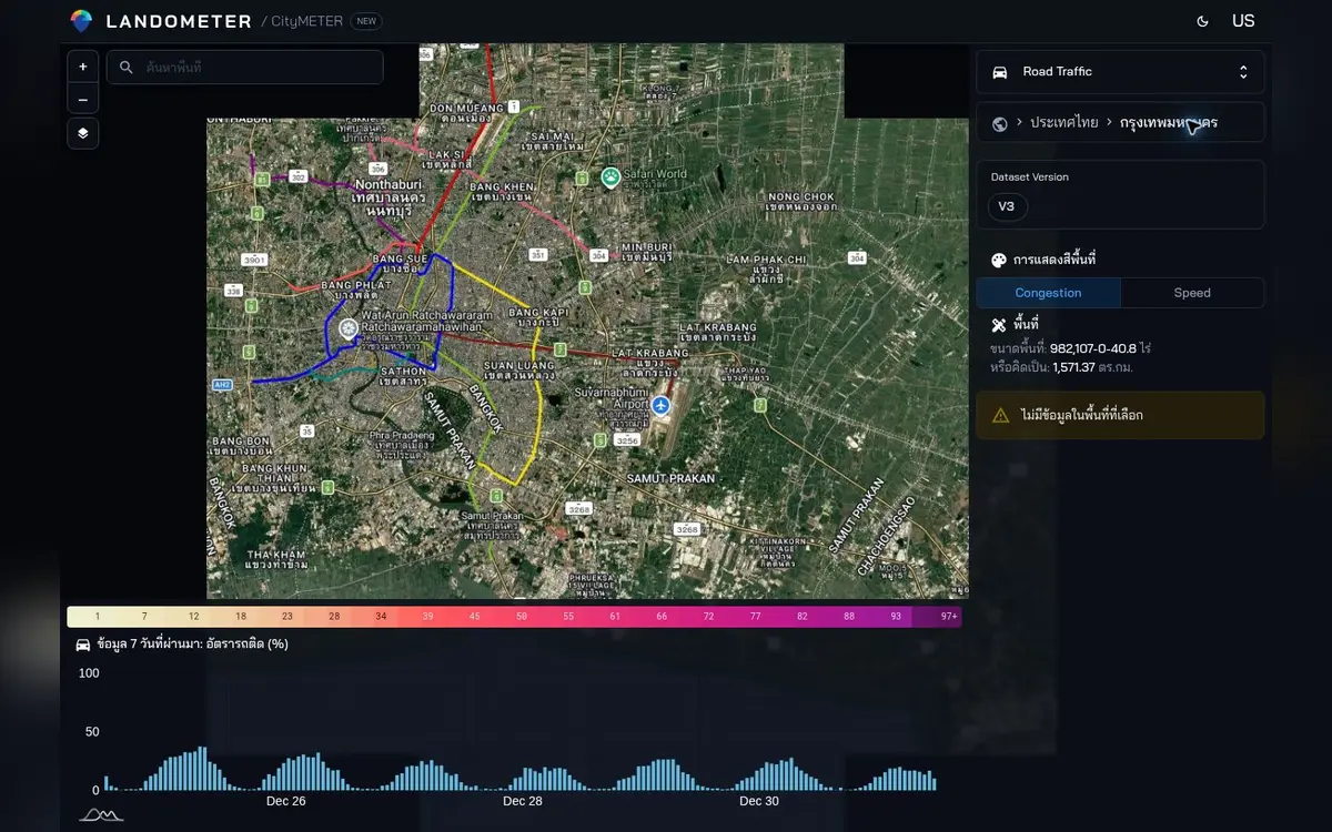
External context: TomTom Traffic Index 2025 · publisher-defined City boundary · read CityMETER speed/congestion with the displayed timestamp and feed status.
- Data period
- Timestamp displayed in the data view
- Coverage
- Bangkok data route
- Level of detail
- Read the details in sources
- Publisher
- TomTom Traffic · processed by CityMETER
The same distance, a different time window
The same report gives 25 minutes 45 seconds for a 10-kilometre morning-rush journey and 31 minutes 25 seconds in the evening rush. For a commute, appointment or site visit, it raises a useful question: does the period being studied match the period when the journey needs to happen?
Put a time window into the location question
When studying a site or service location, begin by identifying when the relevant journey needs to happen: the start of a working day or a proposed visit window, for example. Then read available speed and congestion records whose timestamps are explicit. This gives a route more context than its length alone and helps colleagues agree on the journey being considered. It also shapes the next observation. A team can decide which period deserves a visit or further evidence, instead of comparing records gathered at unrelated times and trying to explain the difference afterwards.
Give speed and congestion a specific job
The CityMETER traffic view supports investigation of speed and congestion when feed records are available for the selected period. Carry the reference time into the assignment and note which route or area deserves follow-up. If several places are compared, use consistent periods and measures so another person can understand the selection. The intended result is a more specific access question. It might concern the timing of a field visit or the period in which a service journey should be observed, with the available records providing a dated basis for planning that enquiry.
Observe the journey that matters to the work
Before going out, define the starting point, destination and period relevant to the assignment. Decide what to observe, including the approach to the entrance and any appointment with the people responsible for the site. Afterwards, retain the time and conditions of the visit with the route note. The team can discuss access through an identifiable observation, while keeping the city-report example, the traffic view and its own field evidence distinct. Each contributes something different. Together they help replace a vague judgement about distance with a clearer enquiry about a journey people actually need to make.
Explore your own place
Define the route and time window relevant to the work, read matching timestamped records and plan an observation of actual access.
Sources and reading notesPublisher, period, coverage and references
Specialist source
- Data publisher
- TomTom Traffic — processed and presented by CityMETER
- Source
- Uses speed and travel-time data from TomTom Flow Segment Data, with congestion calculated against free-flow speed. Area coverage and continuity depend on the records collected.
- Data period
- Read the timestamp and available history on the data view. Missing or old records do not establish free-flow traffic.
- Coverage
- Bangkok data route
- Level of detail
- The smallest supported geography is not yet verified from the public page
Read the references
Further notes for comparison or citation
Old or missing data does not mean clear roads. Traffic values do not measure customers at a shop.
A delayed or unavailable feed does not mean free-flow traffic, and no public update SLA is stated
Use only with timestamp and feed status visible; delayed or unavailable data does not mean free-flow traffic.