Land· CityMETER · Thailand
Before a housing estate becomes a place to live
Registered Housing EstatesThe Thailand view shows 19,753 registered housing projects containing 2,689,950 plots. Projects and plots describe different scales of development. Reading both turns a collection of map pins into a more useful picture of how housing has been organised.
A view inside CityMETER
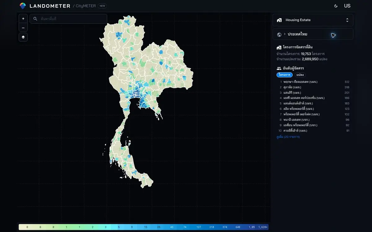
Thailand view inspected on 10 October 2026 · registered projects and allotted plots in the displayed inventory.
- Data period
- Monthly land-allotment records
- Coverage
- Read the details in sources
- Level of detail
- Registered developments · plots · developers
- Publisher
- Department of Lands
A project count is only the beginning
One registered project can contain a very different number of plots from another. Seeing both units helps a reader move beyond the number of project names and examine the structure of the development inventory. For a team studying an area around a site, that distinction shapes which records to investigate first. A developer name and a permit record provide a route into the relevant documentation. They give a conversation about the neighbourhood a shared reference, before the discussion moves to the streets and homes that can be seen there today.
Read the relationship between places
The map places projects in relation to one another. A prospective resident might begin with an area connected to daily destinations; a service-planning team might begin with the boundary of a field assignment. Nearby records can then be grouped into questions about access and surroundings. There is no need to investigate the entire national inventory at once. Its value is to provide a way into a tractable area, where a team can inspect documents, arrange visits and speak with the people responsible for the developments it has identified.
Follow the paper trail
A registration record becomes especially useful when it can be followed back to the project, developer and document it describes. Keep the name and identifier together. This helps distinguish similarly named developments and separate records that might belong to different parts of a wider scheme. It also makes a handover easier: a colleague can see which document needs attention and add the answer to the same investigation. The record becomes a thread connecting the map, the file and the next conversation, rather than another isolated item in a spreadsheet.
Make a small, workable field agenda
Almost twenty thousand projects convey the scale of the displayed register, but a useful result for one person may be a shortlist of only a few. Choose an area, retain the relevant project and plot records, and use them to organise document checks and visits. Afterwards, add what the visit establishes alongside the registration information. This is how a large inventory can become local knowledge: through a bounded set of records, clear references and observations that remain attached to the places where they were made.
Explore your own place
Choose an area and compare project counts with plot counts, then follow the documents and present condition of the selected developments.
Sources and reading notesPublisher, period, coverage and references
Reference checked
- Data publisher
- Department of Lands
- Source
- Project, permit, developer, title-document and plot fields match the official land-allotment permit dataset.
- Data period
- Monthly nationwide coverage; this card uses the land-allotment part of the package.
- Coverage
- Geographic coverage is not stated on the public page
- Level of detail
- Registered development, plot count and developer
Read the references
Further notes for comparison or citation
Registration does not establish construction completion, available units or current occupancy.
This represents registered estates and should not stand in for every housing development
Use it for permit history and project distribution. A permit does not prove completion, current availability or occupancy.