Land· CityMETER · Thailand
A map that leads into 1,853 environmental-assessment records
EIA Projects & ReportsThe Thailand view contains 1,853 project records: 168 IEE, 1,665 EIA and 20 EHIA. Seeing where those records sit provides a practical way into the environmental documents behind development, especially when the question starts with a particular place.
A view inside CityMETER
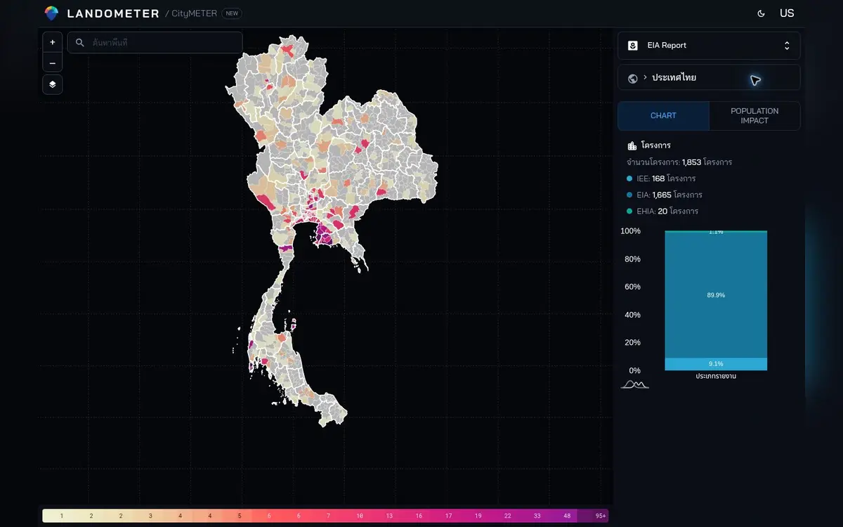
View inspected on 10 October 2026 · project records by IEE/EIA/EHIA assessment type in the displayed inventory.
- Data period
- Report year of each project
- Coverage
- Read the details in sources
- Level of detail
- Projects · IEE / EIA / EHIA
- Publisher
- ONEP
Begin with the place, then find the document
Someone trying to understand development around a home or work site often starts with the name of a place, rather than the title of a report. Mapping the project records connects those two starting points. Once a relevant location is found, its project name, owner and assessment type help organise the next search. This gives a large collection of documents a manageable boundary. It also lets people discuss the same project without relying on a rough description of what they remember seeing nearby or a name that may have changed in conversation.
The assessment type gives the reading a direction
IEE, EIA and EHIA are part of the context of each record and should travel with it. The 1,665 EIA entries show that this type dominates the displayed collection, but the project relevant to a particular question may belong to any of the groups. Start with place and project identity, then read the date, status and associated document. This keeps the investigation focused. A national breakdown can explain the composition of the collection; the specific project record determines which material a reader needs to examine next.
Turn a project record into specific questions
When the document is open, connect the original question to the relevant part of the report: its project boundary, transport considerations or surrounding area, for example. A precise question moves a conversation beyond whether something is simply near or far away. If several people are working together, retain the document date and the page or section used. Another reader can then return to the same passage and judge how directly it addresses the question. The map has done its first job by finding the record; careful reading does the next.
Keep the route back to the evidence
A useful outcome may be a short note about a single project: its location, assessment type, report link and the question that needs follow-up. That note can support a site study or help someone explain a development to other people. The 1,853 records matter because they provide routes into evidence. Their practical value comes from completing one of those routes—taking a place-based question to the right document, preserving the reference and giving the next reader a clear point from which to continue.
Explore your own place
Choose a project near the area of interest, open its original report and record one question with the document date and relevant section.
Sources and reading notesPublisher, period, coverage and references
Reference checked
- Data publisher
- ONEP
- Source
- Project, owner, report type, document, approval date, category and location fields match Smart EIA.
- Data period
- Project years and coverage depend on the imported records; check the report date and status of the project of interest.
- Coverage
- A Thailand summary view is visible; source coverage is not stated
- Level of detail
- Project records and their IEE, EIA or EHIA assessment type
Further notes for comparison or citation
Mapped records do not establish current approval, construction progress or compliance with environmental measures.
Use for initial context, not as a determination of development rights or approval status
CityMETER is a curated, geocoded snapshot. Approval does not prove construction, operation or current compliance.